Land Use Imitates Art

JSRCenitEMUSqtwm

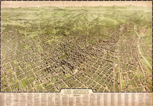
Here’s a three-dimensional, color map of Los Angeles, in 1909. It’s interesting. You can see the urban core that was beginning to take shape: the concentration of zero-lot line buildings, the canyons of concrete, the traditional green squares, the grid of warehouse blocks near the railroad tracks. Had it not been for the interruption by history — motor vehicles, modern zoning — a more traditional big city might have evolved there.

Here are a couple of surviving examples that I found of urban fabric in the core of Los Angeles, from which you could kind of envision an alternate pattern of how Southern California might have developed:

Broadway / 7th Street, Los Angeles.

Spring / West 4th Streets.

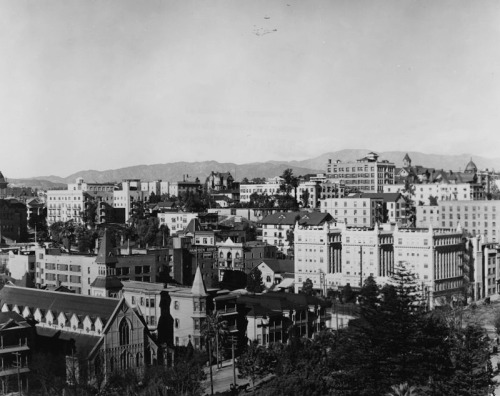
Just north of the urban core is Bunker Hill. You can see it in the bird’s-eye view, above, where the land rises behind the dense grid of streets, and the structures transition from commercial to residential. Most of what was once there is gone today. Here’s an old photograph, looking across Pershing Square:
Downtown-LA-1900

Raymond Chandler described the late stages of the neighborhood’s decline in his 1942 novel, The High Window, as only he could do:

Bunker Hill is old town, lost town, shabby town, crook town. Once, very long ago, it was the choice residential district of the city, and there are still standing a few of the jigsaw Gothic mansions with wide porches and walls covered with round-end shingles and full corner bay windows with spindle turrets. They are all rooming houses now, their parquetry floors are scratched and worn through the once glossy finish and the wide sweeping staircases are dark with time and with cheap varnish laid on over generations of dirt. In the tall rooms haggard landladies bicker with shifty tenants. On the wide cool front porches, reaching their cracked shoes into the sun, and staring at nothing, sit the old men with faces like lost battles.

In and around the old houses there are flyblown restaurants and Italian fruit stands and cheap apartment houses and little candy stores where you can buy even nastier things than their candy. And there are ratty hotels where nobody except people named Smith and Jones sign the register and where the night clerk is half watchdog and half pander.

Out of the apartment houses come women who should be young but have faces like stale beer; men with pulled-down hats and quick eyes that look the street over behind the cupped hand that shields the match flame; worn intellectuals with cigarette coughs and no money in the bank; fly cops with granite faces and unwavering eyes; cokies and coke peddlers; people who look like nothing in particular and know it, and once in a while even men that actually go to work. But they come out early, when the wide cracked sidewalks are empty and still have dew on them.

The urban fabric of Bunker Hill was almost completely demolished in the 1960s under a massive redevelopment plan. For a sense of what was lost: George Mann, a Los Angeles photographer, took this picture in 1959:

4653171282_5f2d7f67fb_o

Grand Avenue / 2nd Street. Photo by George Mann, courtesy of Dianne Woods and the George Mann Archives. (Fair use.)

Update: The Lost Public Baths of New York City

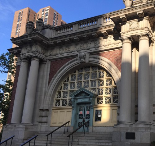
IMG_3278A few years ago, I wrote a short piece about the lost public baths of New York City. Built around the turn of the 20th century, the public baths were meant to address the lack of sufficient bathing facilities in areas with (1) high concentrations of old-law tenements and (2) no public beaches. They were concentrated on the east side of Manhattan.

This summer, I came across one of the bath buildings that still remains. Here’s a picture that I took on July 4th of the Free Public Baths at 23rd Street and the East River, which has now been converted into a public swimming pool. Still, the original inscription remains on the architrave:

FREE PUBLIC BATHS | CITY OF NEW YORK

The mix of tenements that once characterized the area — and which gave rise to the public baths — is long gone. The adjacent super-blocks are now occupied Peter Cooper Village (a formerly middle-income housing development) and the VA Hospital.

Here’s the structure, and its context, on Street View:

Anti-Urbanism and Edward Hopper?

Night Shadows. Edward Hopper (1921).

Night Shadows. Edward Hopper (1921).

I recently read Tom Slater’s 2002 article, “Fear of the City: 1882-1967: Edward Hopper and the Discourse of Anti-Urbanism.” It’s really a fascinating piece. Slater argues that much of the imagery in Hopper’s art is part of a deep and old tradition of suspicion of cities in the American worldview. Slater claims that a “negative discourse of the city … began with the pastoral musings of Thomas Jefferson and was furthered significantly by the transcendental contemplations of Ralph Waldo Emerson, [and] grew stronger and became embedded in social life through powerful representations of urban malaise in late nineteenth- and early twentieth-century American literature, art, and social theory.” He then closely analyzes four pieces by Hopper — Night Shadows, Nighthawks, Approaching a City, and Sunday — to illustrate his thesis. I strongly recommend reading the piece.

Slater cites Hopper’s childhood in then-rural Nyack, N.Y. as the source of the artist’s skepticism about city life, and he describes the contrast between the ideals of small-town America and the exploding urbanism of large, east coast cities that occurred in the late 19th century. Of Hopper’s relocation to New York City — where he would spend most of his life — Slater writes:

Hopper lived through a time of continuous changes to the cityscape, and changes in the neighbourhood where he lived, Greenwich Village, were as profound as in any area of the city. Hopper was dismayed by the ‘crushing of Washington Square’ by the erection of tall buildings around the park which he saw as ‘huge coarse and swollen mounds—blunt, clumsy and bleaching the sunlight with their dismal pale yellow sides’ (citation omitted). Such signs of unruliness and dislocation were serious violations of all that he had been brought up to believe, that humans should be in harmony with nature and situated away from anything which would disrupt this most Victorian, even puritan, way of existence.

(Slater, 141.)

It seems to me that by the late Victorian period, some of the contrarian hallmarks of early 19th-century Romanticism — especially, the idea that humans should make an effort to live in harmony with nature — had calcified into a set of bourgeois notions of propriety, in somewhat the same way as the countercultural values of the 1960s have been repackaged into the predictable platitudes of Whole Foods advertising, today.

Nighthawks. Edward Hopper (1942).

Nighthawks. Edward Hopper (1942).

Slater sees Hopper’s haunting imagery of dark, foreboding, and lonely urban scenes as part of a long (and presumably unwarranted) tradition of city-hatred in American thought, rooted in this culturally idealized view of nature. He cites this larger narrative as a key source of the American political establishment’s long hostility toward urban interests. In that, Slater identifies something real: There certainly is a tradition in America of ignorant hostility toward big cities. (Is it not the inevitable reciprocal for a country with a frontier mentality to also have some degree of contempt for those who choose to live in more thickly settled locations, rather than strike out for the West — or the suburbs?) But I would hesitate to assign Hopper’s work to that thread. His city scenes are layered: Though often dark and alienating, his settings are also mysterious, enchanting, and beautiful. Inhabitants frequently seem conflicted, or unfulfilled, or stoic, but not necessarily miserable. These internal contradictions remain true of large cities and their inhabitants today. To acknowledge them, and their inherent sadness, is not to malign the city. It is simply to observe it honestly.

Furthermore, one must concede the reasonableness of Hopper’s skepticism — if that’s what it is — about many of the circumstances that he depicted in New York and elsewhere. The early urban planning movement was made up of people whose biases were quite the opposite of anti-urban, and who were driven by precisely the same visceral and moral reactions that Hopper seems to have experienced in response to the excesses of industrial urban life in the late 19th and early 20th centuries. There is something undeniably harsh about a society whose excesses are not tempered by humane concerns. This is something that radical, reformist, and conservative thinkers all observed in Hopper’s time (and continue to observe, today). Its expression is hardly the hallmark of a puritanical, anti-urban mind. More to the point, as I interpret his images, the object of Hopper’s disapprobation is not urbanism, per se, but the heavy industry that pervaded cities in his lifetime, and the rapid change that it imposed on those in its path, including its disruptive impact on the individuals and traditions that required stability and patience to flourish. Though not mentioned in Slater’s piece, House by the Railroad has long struck me as one of the most haunting and tragic of all Hopper’s works. Notably, it is set not in a large city, at all, but in the small Hudson Valley town of Haverstraw, N.Y.:

Edward Hopper. House by the Railroad (1925).

House by the Railroad. Edward Hopper (1925).

Slater’s article is fascinating on many levels, and I strongly recommend reading the entire piece.

What on Earth are These Land Parcels?

In contrast to the orderly subdivisions of East Coast cities, or the predictably square farms that dice up the countryside of the rural Midwest and Texas, variations on the above mish-mash can be found on tax maps throughout the Intermountain West: long, rectangular parcels — some overlapping others — with no apparent rhyme or reason. Apparently, these parcel patterns are the legal remnants of old mine claims. Here’s a map showing claims in the Leadville, Colorado vicinity as of 1880:

COLeadvilleMines

1880 mine claims around Leadville, Colorado. Source: David Rumsey Map Collection.

This map makes you realize how intense the American mineral rushes really were. Claims covered every inch of land in the promising places, and even overlapped each other as new claims supplanted abandoned ones — or maybe the claims just conflicted with one another in the legal vacuum of the old West. The names claimants gave their mines are usually funny — names like Dead Broke and Legal Tender, Last Chance and Grand Prize.

Apparently, the similarities between the dimensions of different miners’ claims is not coincidental: Legislation at both the federal and state levels had attempted to standardize the rules for mining claims on a number of occasions; these efforts culminated in the U.S. General Mining Act of 1872.

Spotlight: Cripple Creek, Colorado

From Wikipedia:

At an elevation of 9,494 feet (2,894 m) and just below tree line, for many years, Cripple Creek’s high valley was considered no more important than a cattle pasture. Many prospectors avoided the area after the misnamed Mount Pisgah hoax, a mini gold rush caused by salting (adding gold to worthless rock).

On the 20th of October, 1890, however, Robert Miller “Bob” Womack discovered a rich ore and the last great Colorado gold rush began. Thousands of prospectors flocked to the region, and before long W. S. Stratton located the famous Independence lode, one of the largest gold strikes in history. In three years, the population increased from five hundred to ten thousand by 1893. Although half a billion dollars’ worth of gold ore was dug from Cripple Creek, Womack himself would die, penniless, on 10th August, 1909.

For the past 16 months I’ve been researching local business regulations around the United States. In the course of the work, I talk with police chiefs and mayors, and I read a lot of municipal ordinances. Over time, it’s become a telephonic tour of America.

Cripple Creek, the seat of Teller County, is a great example of late Victorian frontier architecture and town planning. It almost became a ghost town in the 1960s, but it’s apparently made a comeback with gambling and historical tourism.

Old Urban Rail Movies: NYC and SF


The above video shows the subway line from Union Square to Grand Central, in 1905. This would be the route taken by the 4, 5, and 6 trains, today; the Lexington Avenue IRT. According to the Library of Congress:

The camera platform was on the front of a New York subway train following another train on the same track. Lighting is provided by a specially constructed work car on a parallel track. At the time of filming, the subway was only seven months old, having opened on October 27, 1904. The ride begins at 14th Street (Union Square) following the route of today’s east side IRT, and ends at the old Grand Central Station, built by Cornelius Vanderbilt in 1869. The Grand Central Station in use today was not completed until 1913.

The clothing at the end is incredible. After the route covered by the video, the train would have turned west, and followed the shuttle tracks to the West Side, where it would have continued north along the tracks now used by the 1, 2, and 3 into Harlem and Washington Heights, and eventually the Bronx. This was before there were tunnels under the rivers to Brooklyn, Queens, or Jersey City. As the subway grew northward, it would include architecturally unique stations like the one at 168th Street, whose design echoed the tepidarium of the Pompeiian baths:

DSC00308

The deepest, oldest level of the 168th Street IRT station in Manhattan.

(It’s interesting how much more front-and-center the references to the Classical world once were in American city planning.) In spite of being the only subway, the first line existed in the context of an established and extensive elevated system, which had provided above-ground urban rail to New Yorkers since the mid-Victorian period; and also electric streetcars. The NYC video is kind of like a subterranean version of the below movie, which was filmed from a San Francisco streetcar, on Market Street, traveling towards the Embarcadero, just days before the infamous earthquake in 1906:

This is the route now followed by the underground BART. Great stuff.

Another One

My cousin recently found an apartment near this surviving NYC detached Victorian-type house. The Victorian sits on an oddly shaped corner lot at Briggs Avenue and East 201st Street. The owner seems to like gardening, and there is at least one well-fed cat living in the yard. It’s two blocks down from the Grand Concourse, and it’s in much better shape than most of the similar houses on Woodycrest Avenue in High Bridge. Unfortunately, it’s not part of a cluster. There are some other detached houses nearby, but they’re not of the same style or period.

Update: I’m using Google Maps Engine now to create a database of these houses. Since there are thousands of examples of Victorian architecture in New York City, here are the criteria, for now:

1. The structure must have been built within the legal boundaries of the pre-1898 City of New York. That is, the present-day borough of Manhattan, or the portion of the present-day Bronx that lies west of the Bronx River.

2. For the time being, I’m going to cut off the year of construction (if determinable) in 1910, because there was a burst of this type of construction around the turn of the century. (So, we’re actually looking for Victorian and Edwardian-era houses.) I don’t want to exclude structures that were part of an organic phenomenon, simply because the city’s legal boundaries were expanded to include other, non-NYC-proper phenomena (e.g., Brooklyn, Flushing, etc.). But at some point, I may create separate categories for pre-1898 and post-1898 houses.

3. The structure must be (or show evidence of having once been) a fully-detached house. Evidence could include side-windows and façades, and side yards that are (or clearly were) more than mere alleyways.

4. Finally (the fun part), the structure must show evidence of Victorian-era (especially, American Queen Anne-style) architectural details, such as cones, turrets, towers, stained-glass windows, bays, wraparound porches, asymmetrical façades, and the like — or strong evidence that such features were originally incorporated into the structure, but have since been modified or removed.

And, by all means, please send along any new finds that meet the criteria!

A Snapshot of the City in 1885

NYC1885-1
I thought this Britannica map of the New York Harbor area in 1885 was pretty interesting. It shows how the West Bronx had been incorporated into the city long before Brooklyn, Queens, Staten Island, or the East Bronx would be — and why the remaining detached Victorian houses in that area are significant to New York City‘s urban history, as opposed to the separate histories of Brooklyn or Flushing or other towns that were unfolding during the same time period. Mainly because of its shape, the map also gives a good look at where the larger cities in North Jersey were at the same time.

I like the inebriate and lunatic asylums on Ward’s Island. And also the way that the cartographer jumped the gun on the first Hudson Tube (showing a “Tunnel” between Greenwich Village and Jersey City). That’s not entirely wrong — it actually was been being attempted in 1885, and the mapmaker probably didn’t want to leave off an important project. But due to legal, financial, and engineering challenges, it wouldn’t be finished until 22 years later, in 1907.

Update: I found a companion plate that shows the details of Manhattan below Central Park. It includes the names of the ship lines on the Hudson River and East River piers, and Thirteenth Avenue.

LowerManhattan1885