DC’s Continental Urban Notes

K Street NW toward New York Avenue, from Ciel, a rooftop restaurant.

Engage with this post on Substack.

I’ve spent some time in D.C. this year — mainly for work. I’m not quite an Acela commuter. It’s usually the more proletarian Northeast Regional. Which is fine. On the corridor, it only takes a few minutes longer between cities. You realize how compact we are in the Northeast.

Washington is the great city on the Eastern Seaboard that I’ve had the least time to explore. New York is home; Boston was, sort of, for about a year in my 20s; and Philly has been home to enough friends from Rutgers and elsewhere to almost feel like a place I’ve lived. But D.C. has remained a bit of a mystery. My visits over the years have tended to be packed with sights to see, and things to do; but it is in ordinary time that one really gets to know a place. Still, with several work meetings and a couple of evenings around hotel nights, I’ve begun to tentatively observe a few things about its urban personality.

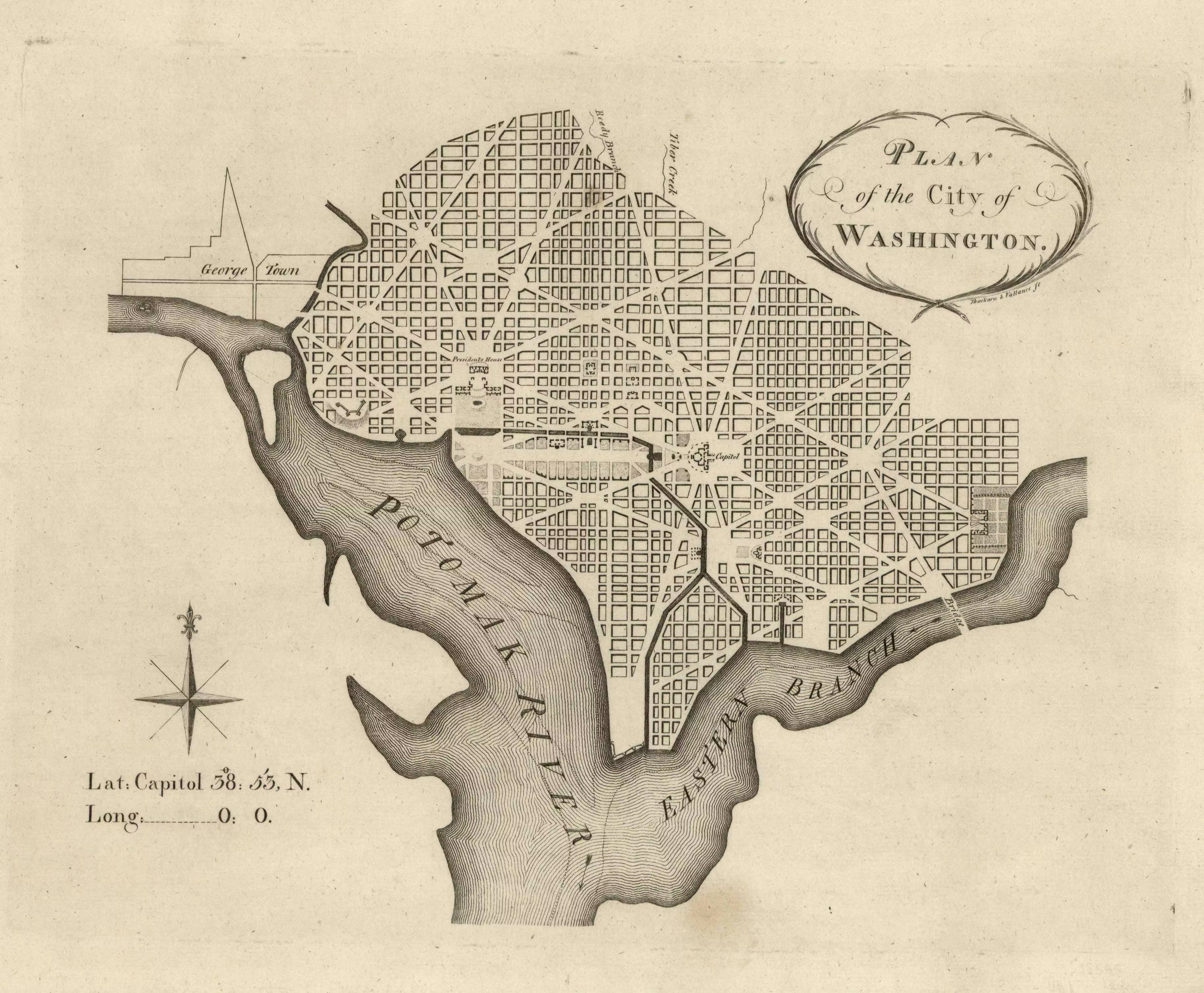
From a spatial perspective, DC’s proportions feel more like those of a European capital than a typical American city in 2025. Undoubtedly, this is due in part to L’Enfant’s many wide avenues, running off at all angles from the Capitol and the Mall; and the squares and triangles with monuments where those avenues intersect.

L’Enfant’s plan for Washington.
Neptune in a fountain near the Capitol.

There is also the quirk of the city’s mandatory low skyline that has driven new development to happen in a more traditional urban pattern, with side-by-side building facades forming continuous street walls. In its details, the city is quite a bit more American — the chain stores, the people — but its massing has a certain quality that is reminiscent of Madrid or, or a district like Prati, in Rome.

Buildings on Connecticut Avenue NW.

There is a lot of housing being built. Right now, this is especially true in the blocks north, west, and east of Union Station. An entirely new urban fabric is being assembled, one lot at a time, that is quite impressive. If only New York City could remember how to build like this, we might not have such a housing crisis. (A century ago, it did, in Harlem and the Bronx.)

New housing in NoMa, northwest of Union Station.

It seems that the area — which straddles NoMa and the Near Northeast — was largely composed of small row houses until the past decade; and many of these old homes, as well as vacant lots, are now being replaced with large apartment houses in a pattern that mirrors a traditional urban process. (That said, the transformation is being managed by heavy regulation — contrary to traditional urbanism).

New apartments along the Northeast Corridor in the Near Northeast. Older row houses survive on the central block, amid the growth.

As a cumulative effect of these changes, the area called NoMa is beginning to show massing patterns that resemble the older urban core, to the west (i.e., Metro Center, Downtown, Adams Morgan) — defined by 8-12 story buildings, attached into continuous street walls, and sustaining strips of ground-floor retail that opens onto the sidewalk. The architecture is, of course, nontraditional. East of the tracks, the Near Northeast has a bit further to go before the new development congeals.

New buildings in NoMa.

It is an interesting city to explore. Will share a few more images:

An old pub in Dupont Circle, with newer buildings (subject to the height limit) beyond.
NPR offices, North Capitol Street.
Standing guard at Union Station.
Street signage and a lamppost, with new housing beyond

LegalTowns is a reader-supported publication. To receive new posts and support my work, consider becoming a free or paid subscriber via Substack.

Olmsted’s Brooklyn Comes to Life

In spring, especially, the boundary between Prospect Park and the gloomy, earth-colored blocks of Park Slope is fluid. It is one of the most perfect intersections of 19th-century Romantic landscape architecture and late Victorian common-law urbanism. Viewed on a map, a monotony of gridded blocks makes the boundary between urbs and gardens look like a hard line, defined by the long razor of Prospect Park West. But a few images from a recent visit prove that it is, in fact, a more subtle transition.

Situated within the park, near Prospect Park West, the Litchfield Mansion (1855) predates both the park and the subdivision of urban building lots for Park Slope. A placard teaches that it was once the private home of a Brooklyn industrial magnate. Today it serves as administrative offices for the Parks Department.

The trees of Prospect Park were in full bloom when I visited. The Long Meadow, beyond the mansion, was busy with people, some playing games, others having picnics, a few reading beneath trees.

At the edge of the park, one can see that its influence does not merely end at its surveyed boundary. Instead, the density of trees and plant life, and the colors of nature, extend across Prospect Park West and echo through the cool, shady blocks of the old Victorian neighborhood.

Here is the park block of First Street, afternoon light filtering through the leaves:

And some wavering cornices on the same block:

In early spring, the old trees had already formed canopies more reminiscent of Oglethorpe’s Savannah or of New Orleans’ Garden District than of New York City:

Here are some facades on Third Street, between Eighth and Seventh Avenues:

Massive, hundred-year-old sycamores make parts of the Central Slope feel like a quiet, settled place in the woods — rather than a major city. The cool, enchanting gloom is hard to capture inside the four corners of a picture.

In some blocks, these ancient trees not only line the curbstones — but a second row also occupies a position closer to the building line:

Park Slope is a richly tactile place, with block curbstones, wrought iron gates, gnarly tree trunks, and (in some places) traditional slate sidewalks.

The topography — including the namesake slope — can be seen in the terraced rooflines of the area’s east-west blocks.

In parts of the Central Slope, the street trees are truly massive:

Back in the park at twilight, the buildings of Prospect Park West form a street wall that helps to define the green space.

Four-story buildings front the park on Prospect Park West.

Unfortunately (or fortunately, depending on one’s perspective), zoning and historic preservation have, at the southern end of the park, frozen a relatively low density of development in place.

The continuous street walls that were built early, further north, become shorter as one approaches Bartel Pritchard Square, and as one moves southward along Prospect Park Southwest they begin to show gaps. The lower-rise buildings in these blocks may have merit, but they are not the unbroken cascades of perfect brownstones that served as the basis for the historic district, nor are they the highest and best use of prime park-front building lots. The persistence of gaps in the street wall here, and the sense it projects of incomplete urbanization, illustrates how a traditional urban process was interrupted by 20th-century regulation.

Prospect Park Southwest has not developed a continuous street wall. Image: Google.

Be that as it may, the transition between the western edge of Prospect Park and the Victorian urban fabric of Park Slope — especially in the North and Central Slope — is one of New York’s treasures of the built environment. It bears noting that this gem of urbanism is an artifact of the mix of private, common-law urban growth processes and municipal planning initiatives that drove the growth of American cities in the 19th century — a development context that has now, mostly, regrettably, been forgotten.

LegalTowns is a reader-supported publication. To receive new posts and support my work, consider becoming a free or paid subscriber via Substack.

Ibn Battuta and the Echoes of Another World

I’ve been reading an English translation of the Rihla, an account of Ibn Battuta’s 14th-century journeys through nearly all the known world. So far, it’s fascinating. Starting from his native city of Tangier, in Morocco, the young lawyer began traveling east on Hajj in 1326: first across the Maghrib, then meandering through Egypt and the Levant, and finally turning south into the Hejaz.

Along the way, Battuta offers a sort of Grand Tour of the Medieval Islamic world: bustling urban Tunis (at roughly the time of Ibn Al-Rami, whose treatise on urbanism Besim Hakim introduced to Western readers); the last days of the crumbling ancient Pharos (that Wonderous lighthouse) at Alexandria; the maritime Nile waterfront of Cairo; the Dome of the Rock and other notable sites at Jerusalem; the cosmopolitan markets and charitable largesse of Damascus; and the long Incense Route through the ancient oases towns of the Hejaz — including Hegra and Al Ula.

Mada’in Sâlih (Hegra), Medina, Kingdom of Saudi Arabia (2022).
The oasis at Al Ula, Medina, Kingdom of Saudi Arabia (2022).

Battuta wound up, as a matter of course, at the Mosque of the Prophet at Medina; and next, at his destination, he provided a fascinating account of the city of Mecca, itself, and its people, and their ways. But unlike most pilgrims, in his time or today, Battuta did not promptly return home after completing his religious obligation. Instead, he kept traveling, first with a caravan across the desert, following an eastern Hajj route, the Darb Zubayda, developed and supplied with way stations and water infrastructure by an earlier Abbasid princess; then southeast through the reedy wetlands occupied by the fierce ancestors of today’s Marsh Arabs; northeast through genteel Basra; down the Shatt-al-Arab, where the waters of the Tigris and Euphrates finally come together and exchange the outflows of the Fertile Crescent with the salty tidewaters of the Gulf; around the cities of western Iran; and finally back west to a wrecked Baghdad, in the aftermath of a siege by the Mongols — where I have recently left him on the banks of the Tigris, contemplating the destruction by the Khans.

Ibn Battuta, depicted by Léon Benett (1878).

The Table of Contents tells me that Battuta’s travels will yet take him back to the Hejaz; to Yemen; to “Rum” — that Greek-speaking remnant of the Roman Empire we’d call Byzantium, centered on Constantinople; to India and China; and later to Al-Andalus; and to the interior of Africa. And while he lived in some places for quite some time (on a second visit, he spent three years at Mecca), Battuta traveled for the better part of three decades. Anything to avoid going home to practice law, I suppose.

The Rihla also illustrates the different priorities around which a dominant society can be organized. Early in his travels, at least, Battuta found convents and religious orders in nearly every town and city, supporting countless scholars, and providing hospitality to traveling strangers. Most of these stopping-off points were supported by charitable trusts, having been established by merchants and aristocrats. Contrast this dense constellation of oases from the marketplace in the 1300s Islamic world with the hyper-Florentine values of the postmodern West, where deeply human, non-material pursuits like scholarship, travel, and spirituality must typically be self-financed. Definitions of the sacred and the profane do vary.

The Living Music of New Orleans

I was impressed by the vitality of live music in this city. In the evenings, nearly every bar had music. Not surprisingly, jazz and blues predominated, but other genres could be heard as well. And practically everyone I heard was good. Here are some photos, mostly from Faubourg Marigny, but also from outside the French Market and inside the Hotel Monteleone in the Vieux Carré. I probably spent the longest time at Bamboula’s. That’s not saying much — three complete sets (and a couple of Sazeracs, the high price of entry).

Here’s a sample of the Midnight Ramblers at Bamboula’s — skip to about 1:11 for the classic “Bill Bailey, Won’t You Please Come Home?

Blue Nile and Apple Barrel had some enchanting sounds spilling out onto the sidewalk, as well — which led me into each venue briefly.

Midnight Ramblers at Bamboula’s.

A later set, great music, didn’t catch their name.

Here’s an extended sample from the Hotel Monteleone’s Carousel Bar (with a bit of the carousel, below):

A Haunted and Enchanted City

I spent part of last week in New Orleans — my first time in that city. The photos included in this post are mostly of architecture and a few street scenes around the Vieux Carré. I’ll post other batches, including of jazz clubs, houses in the Garden District, and the enchanting light that came over the streets during an impending and fierce storm (including a visit to the again-going Old Absinthe House) in a later post.

A group of young women, dressed as angels (with iridescent haloes), congregate in front of the St. Louis Cathedral to prepare for a Joan of Arc-Twelfth Night parade that also marks the start of the Mardi Gras season. Photo: Theo Mackey Pollack.

I hope to spend time in New Orleans, again. It is a fascinating city to explore, and to try to process, on so many levels: its architecture and urbanism, its layered social and cultural history, the surprising way in which its high culture, cheap alcohol, traditional Catholicism, hedonism, classicism, neon, jazz, old money, abject poverty, and all else seem to (mostly) gracefully coexist. It reminds me of no other place in America, yet it could not exist in any other country.

The streets of New Orleans (at least, those in the Vieux Carré) are reminiscent of a Mediterranean city, maybe one in Spain, with low rooflines and floral balconies and breezy palms, and everything organized on a grid around a central plaza (anchored, of course, by a fine old church). Other aspects seem not-quite-American: many people dress more carefully in New Orleans than most Americans do elsewhere (except, perhaps, Boston). Streetcars still operate. Alcohol is everywhere in public. As is live music. And, in stark contrast to the genericism that has now conquered much of the United States, the local culture here struck me as the most vital I’d encountered in the States. That is, people participate in it. (Following the image above, an entire parade, including floats and more costumery, sponsored by a local krewe, would arrive.) Yet, for all its distinctions, it is a distinctly American city, combining influences that have only ever converged in this corner of the Deep South.

There were moments when I felt like I had opened a time capsule and entered a world where the twentieth century hadn’t quite arrived. Instead, this potent preserve of Victoriana and Vaudeville was floating obliviously on the sea of 21st century America. I’m sure such an impression is engineered by the tourism bureau; and pressing beyond the confines of historic neighborhoods would yield plenty of evidence to the contrary. But with such a concentration of historic spaces, inside and out, and so many people still participating in centuries-old traditions, any line between fantasy and living memory, like other contrasts in this strangely familiar city, can seem ephemeral.

Hover over or tap the image below for slideshow.

Vieux Carré

London: Work + Exploring

Our group made a quick trip to London last summer (2022) to meet with a collaborating team that’s based there. I stayed a few extra nights because I wanted to explore the city a little bit. Fortuitously, my visit coincided with an infamous heat wave in which temperatures hovered around 100° F: not the most pleasant walking-around weather. But I determined to make the best of my brief visit, and to take some photos that captured the city’s beauty, history, and spirit — and of course its urban form.

I stayed near Victoria Station. Many of these photos are from three walks originating from the hotel and reaching into Lambeth, Westminster, St. James Park, Hyde Park, and Belgravia. The fourth and longest (after the heatwave had broken) began in Whitechapel. Heading into the City, I went down to the embankment near the Tower and followed the Thames up to around the Monument and St. Mary Woolnoth. From there, I roughly followed the Roman Wall to the Barbican, then headed back down toward St. Paul’s. (By then, I was exhausted enough to hail a taxi back to the hotel).

A few small takeaways about London’s urban personality:

  • The Thames is London’s Grand Canal: functional, focal, and eternal. The urban fabric builds out from its banks.
  • The meandering streets, like so much that is English, evoke the benevolent chaos of plants: their roots and branches are of a piece with England’s common law, language, and gardens. For all its modernity, England is a deeply agrarian place.
  • In July, there are lilacs everywhere: little shocks of purple against stone walls. The whole city has a floral and smoky scent, a mix of lilacs, gardens, European perfume — and city smoke.

Community and Microcosm in NoVa

An LT reader and fellow urban writer based in the DC area, Bryce Tolpen, has launched a new Substack called Political Devotions. One of his first podcasts, “Stories & objects”, explores a global community that has coalesced around Columbia Pike in Arlington, Virginia; and how an arts space in a strip mall, StudioPause, came to serve as a neighborhood focal-point in the post-2020 American anomie that may never quite end. Such an interesting piece — check it out, along with the rest of Bryce’s writing and podcasts. He is a great storyteller, and writes with a perspective that incorporates a thoughtful and eclectic range of influences.

The Decline of Chinatown’s Bilingual Street-Name Signs

I’ve always liked New York’s Chinatown, and its unique, bilingual riff on standard street-naming has highlighted the special qualities of this neighborhood for as long as I can remember — distinguishing its corners from those in the surrounding blocks of the Lower East Side and the so-called Civic Center (that cluster of neoclassical courthouses and public buildings centered on Foley Square). So this article at the Times gave me a pang of sadness — zeroing in, as it does, on a small but meaningful detail that I’d also noticed, showing how cities can change slowly, then all at once.

Several years ago, I had the good fortune to work in the Municipal Building, on Centre Street, for some time. Being there daily afforded me frequent opportunities to cover the blocks of Chinatown on foot (as well as the various subparts of the Lower East Side and SoHo), block by block, during lunch hours. I noticed then that the center of gravity was moving eastward, with a commercial nexus increasingly focused on East Broadway, far from the old core along Canal, Mott, and Mulberry Streets.

I also noticed that the new street-name signs were rarely subtitled, like the older ones had been:

Bilingual street signs in New York’s Chinatown, circa 2017. Photo: Theo Mackey Pollack

The Times essay, linked above, covers the history of these signs in the context of the history of the neighborhood. I do hope their decline is not a harbinger of rapid change. There have been rumors that Chinatown could soon be made a target for more intense gentrification; and some has already begun. But because it has not gone full-scale (yet), Chinatown is one of the few places in Lower Manhattan that retains some of the character of an older New York City — a messy, discordant, multilayered urban universe (photos by your webmaster) whose spirit has largely been tamed and curated into submission, elsewhere in the tangle of narrow downtown blocks that once teemed with so much human variety.

That is to say, Chinatown is still New York City, as it was meant to be. And I, for one, hope it will stay that way for a while longer.

Small Projects, Big Cities: An Abundance of Gems

I have a new essay at City Journal, in which I’ve reviewed Jim Heid’s recent book, Building Small: A Toolkit for Real Estate Entrepreneurs, Civic Leaders, and Great Communities. In this ULI Press publication, Heid, a Bay Area developer, offers a genuinely holistic and comprehensive approach to developing city lots (or combinations thereof) as small urban projects. His approach fits within the tradition by which cities have customarily been built: one small piece at a time.

Heid’s exploration shows how building small urban projects remains possible, and can still yield excellent results; but he also illustrates how the bureaucratic, regulatory, and financial parameters of present-day development culture have taken a timeless, iterative, and once-efficient process, and transformed it into something that is often much more difficult and expensive than the proponents of healthy growth should want it to be. This fits, unfortunately, with much of what we have covered at LegalTowns over the years.

On a practical note, Building Small offers readers a wealth of topical templates (hence, the ‘toolkit’ title), covering development tasks that range from structuring a special-purpose entity, to stacking funding from diverse sources, to working with attorneys (and identifying the qualities of good ones). Heid’s book is recommended, especially for planners and lawyers who value the development of coherent townscapes, and whose contributions to code development would be enriched by a clearer understanding of the small builder’s perspective. Small projects make great towns and cities.

Victorian brownstones on Carroll Street in Brooklyn. Most neighborhoods were traditionally developed lot by lot. This practice continued in American cities through the industrial era. While several adjoining lots were often built in tandem, the inherent potential for diversity on a single block, tempered by consistent spatial dimensions, due to building-lot sizes, fostered a balance between a spontaneous richness and an overarching order. This deepened over time, as individual owners modified their structures, or combined lots to create larger buildings with dimensions that were often neat multiples of the most prevalent, smaller houses. This quality of ordered irregularity is typical of older, traditional urban settings, like Park Slope, seen here; it is often absent from master-planned, strictly-zoned communities.